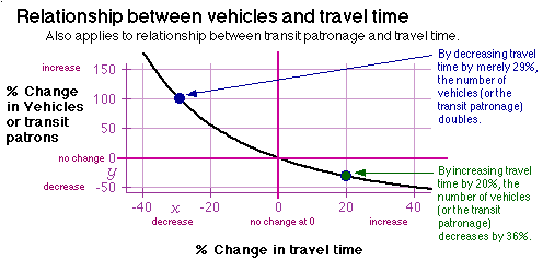
The gravity transportation model is used by government agencies to predict future traffic, and is depicted in the graph below. It relates the number of vehicles and the travel time. Decreasing travel time by increasing highway capacity (e.g., adding lanes) increases the number of vehicles. This soon returns the congestion. The graph below shows the relationship. For example, a 29% decrease in travel time will eventually double the number of vehicles (see blue dot). This effect is called induced traffic. Adding lanes neither decreases congestion nor takes cars of paralleling roads in the long term.
The graph also shows why traffic calming works. Vehicles are greatly decreased by traffic calming. A mere 20% increase in travel time will decrease vehicles by 36% (see green dot). [See links for induced traffic and traffic calming.]
The purpose of transportation modeling is to give decision makers a clear picture of the consequences of each transportation project being considered. The model's primary results are the number of users on the project and the number of users on existing (primarily parallel) routes. Other factors, like air and noise pollution, can be determined by knowing the number of users (primarily commuters) for the type of project.
vehicles = k / time / time
where k = trip generation characteristic.
Looking at ratios instead of number of vehicles and minutes, this becomes
%_change_in_vehicles = 1/(%_change_in_travel_time)2
Note: Transit patronage uses the same equations. Substitute "transit patronage" for "vehicle" in the equations.
1) Divide the geographical region into zones.2) Compute, for each zone, the trip-generating characteristics, such as the number of trip starting points and the trip ending points.
3) Compute, for all pairs of zones, the number of trips between them. This produces the trip table.
4) Assign all trips to the various car routes and transit routes.
The modeling and study of a number of projects for one transportation corridor is called an Alternatives Analysis. A particular transportation corridor might have several potential projects. Examples are light rail transit, 4-lane freeway, 8-lane freeway, or an expressway. A no build alternative is also studied because it is a requirement of federal funding. The last three steps must be done for each transportation alternative, including the no build alternative.
The trip table will be different for each alternative. For example, a freeway alternative will not have the same trip table as the no build case, for two reasons.
First, a change in transportation facilities has an effect on land use. This will change the trip table.Second, the project that gets built will have an effect on people's decisions about where they will work and live. This will also change the trip table.
A simple example of the effect on land use is the fact that the city of San Jose will "trigger" the development of 12,000 homes in Coyote and Almaden Valleys upon completion of Fwy. 85, financed by the sales tax. [Update: the freeway and housing are now built];. The added commuters will have a significant impact on the freeway which caused the houses to be built. One car from each of the 12,000 homes represents 111% of the two-hour carrying capacity of a 6 lane freeway in the peak direction. [Update: After spending years constructing the freeway, it opened with bumper-to-bumper traffic.]
People decide where they will work and live, in part, based on what transportation facilities exist. More freeways will encourage people to live further from work. For example, most people in Coyote Valley (in residential south San Jose) will not now consider taking a job in Palo Alto (a north county job center). At present, it is a 25 mile commute via bumper-to-bumper traffic on freeways 101 or 280. The new Fwy. 85 will significantly increase the number of these commuters. This is because a new freeway would initially decrease the travel time. Travel time and cost, but not distance, are what people use in evaluating whether a commute is worthwhile. As the congestion returns and increases travel time, the incentive for long distance commuting also will decrease. (This is similar to the concept of equilibrium in chemistry.) But the damage will have been done; an increase in the average commute trip length. [Update: just two years after constructing Freeway 85, traffic in the corridor --on parallel local streets-- is worse than it ever has been, according to news reports. Constructing the freeway and its induced sprawl developments actually made commuting worse. Furthermore, the promise of "traffic relief" by the special interests, in order to get the public to pass their proposed sales tax to construct the freeway, is now proven false.]
The calculations to compute the trip table are often referred to as the Gravity Model (see curve above). It states that the number of trips between two zones is inversely proportional to the square of the time that it takes to travel between those zones. For example, if travel time is reduced to half by constructing a new project, then the number of trips (or cars for the case of car commuting) would increase by four times (assuming the price stays the same). In order to double the number of trips, the travel time would only need to be reduced by 29%.
![]()
![]()
![]()
![]()