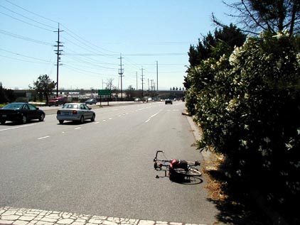
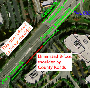
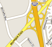
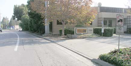
Walkers must use the right turn only lane (westbound side, shown above and top-right of aerial photo) when walking to
the Light Rail (seen elevated) and to Great Mall (top-left of aerial photo). There is no alternative route because of the
hierarchical street pattern.
There is not enough room for both a pedestrian and a motor vehicle in the same lane.
Pedestrians have always been allowed on Montague Expressway,
but in 1989 the shoulders here, used by pedestrians, were eliminated when adding lanes.
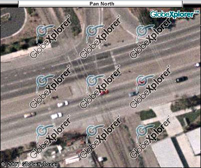
The intersecting street, Piper Dr. is a dead-end. There is no reason for a freeway-style decceleration and an acceleration lane on
a 45 mph arterial road, nor any other arterial road such as Milpitas Blvd (also 45 mph in portions). Solution:
change the right-turn lane back to a shoulder by painting lines, or plant a different shrub that would enable walkers to use a path.
[The bicycle was placed for scale reference. Aerial photo is dated June 2000.]
Update: See recent dangerous action on the other side of the road.
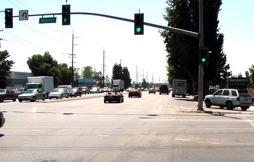
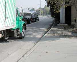
The most dangerous location for pedestrians is an acceleration-merging lane where pedestrians are forced to walk in the traffic flow. As vehicles accelerate (see truck with left turning signal) the driver must look to the left or backwards to merge into traffic, instead of looking in the direction the vehicle is moving. The shoulders that existed previously were eliminated by the County highway engineers. Acceleration lane is not an approved intersection design in the County Expressway Bicycle Accommodation Guidelines, Aug. 2003. This policy also stipulates 16 feet for a shared lane width. The acceleration lane is 13 feet from curb to line. Violation of both policies at the same location exasperates the danger. Solution: paint lines to eliminate the acceleration lane and restore the shoulder. [link to download].
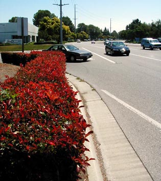
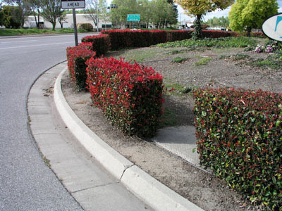
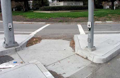
Update: Done. Shrubbery was planted [above, left] at exactly where walking in the vehicular flow is the most dangerous: the curve. A car cutting the corner sharply could easily kill a pedestrian because the driver is looking left as his/her vehicle is turning right. At least one pedestrian has already been killed in this scenario. See the County Policy that prohibits this action. Notice that most of the nice hedge can be kept by creating a path on the other side of the hedge. Update: After many years of ignoring MTS' repeated requests, County field worker Dave Gaska (not Roads and Airports management) opened gaps in the shrubbery in March 1993 [above right] at my request, so pedestrians can walk through the shrubbery instead of in the travelway of a right turning motorist going around the curve. [This intersection is Montague & Sango Ct.]
Pedestrians must step from the sidewalk into the traffic lane (above, left) after walking on the sidewalk built by Caltrans (above, center). The sidewalk ends where the roadway becomes County owned. Location is near 880 looking west. County highway engineers eliminated the pedestrian facility --the shoulder-- circa 2002 when adding more traffic lanes. Notice how the hedge extending into the lane can prevent an approaching motorist from seeing the pedestrian, and vice versa for short walkers (and wheelchairs using the visible ADA ramp).
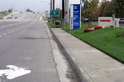
The proper solution would have been to pave the missing sidewalk, because sidewalks already existed most of the way in this block, and a sidewalk or path is required by County policy at freeway crossings [see quote #8]. Photo above is looking at the same block but from the other end, looking east from McCarthy Blvd. Instead of making pedestrians cross the ornamental embankment twice, the proper solution should have been to join the two existing sidewalks. The sidewalk in foreground was constructed by VTA for a mid-block bus stop, now eliminated. The other sidewalk (in triple photo) was built by Caltrans. Shoulders are recognized to be pedestrian facilities by FHWA and BOS policy. When adding lanes, pedestrian facilities need to be relocated and paid for by the lane-addition budget, the same as for relocating telephone poles. Instead, County highway engineers just destroy these facilities, placing people in danger and/or discomfort.
Roads & Airports Department is "asking" right-turing vehicles to hit pedestrians. Brand new porkchop --the pedestrian island at many major intersections including here-- and new curb (on the other side of the crosswalk) were recently built when widening the road to add lanes. But there is a major design flaw. It is well known that large radii curves at intersections --such as pictured-- are risky for walkers. But here it is much worse because County highway engineers prolong the exposure by making people walk in half the trajectory of right turning vehicles instead of just within the crosswalk --unless the ornamental embankment (seen with dirt and grass) is traversed by the walker. Few do. Despite the Great Mall across the street and Light Rail almost overhead, walkers are subject to appalling conditions. Location is at Capitol/Great Mall Ave., NW corner.
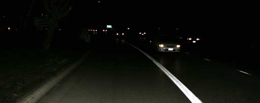
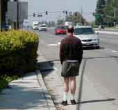
People walk in the acceleration lane even at night, including those taking transit when leaving work in the winter. The acceleration lane is for cars turning from Houret Dr. --and for walkers having no other choice. The walker is not visible in the photo.

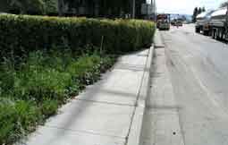
Many companies are directly on the Expressway (including above left). Many others are on dead-end streets with Montague the only access. This lane is only 14 feet wide (line to curb). It does not meet minimum width requirements of FHWA and the BOS for sharing with bicyclists and walkers. The power pole can easily be passed by walkers without entering traffic; the shrubbery cannot. Solution: Enable safe walking access by trimming shrubbery between curb and property line. Also trim vegetation in foreground of left photo, until the shoulder is reached --for about 50 feet. [Location: approaching Trade Zone Blvd. looking east.]
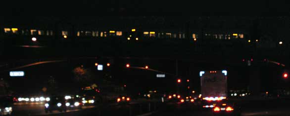
Light Rail trains crossing Montague. There was no consideration that the new Montague Station transit patrons have to use Montague to access nearby businesses and points east and southwest. This occurred despite MTS warning the Department in a letter two years before the new transit line opened. MTS stated that the road needs be made safe by actions detailed above and compliance is needed with the Board of Supervisors policy for pedestrian safety. MTS also met with and showed photos to the Department. Not only was this warning ignored, the Department destroyed even more pedestrian/bicycle facilities on Montague, including just a block from the Montague Station! (shown in the next link).
This report continues with the following links, then a comparison with Foothill Expressway.