Pedestrian path creation and other safety improvements
along San Tomas, an arterial road
MTS letter to Director of Public Works, City of Santa Clara
To: Mr. Yoshino, Director of Public Works, City of Santa Clara
Cc: Ms. Sparacino, City Manager
From: Akos Szoboszlay, President, Modern Transit Society
Date: April 17, 2006
Subject: Safety improvements for pedestrians along San Tomas
Dear Mr. Yoshino:
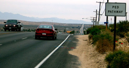
Three weeks ago, I took this photo of Hwy 62 in the town of Joshua Tree in Southern California. Notice the sign "PED PATHWAY". The pathway is the shoulder itself. The purpose of the sign is to inform motorists to watch out for pedestrians because pedestrians would be out of view of motorists approaching this downgrade. The speed limit here is 45 mph, same as for San Tomas.
In sharp contrast to the above sign, the signs on San Tomas stating "PEDESTRIANS PROHIBITED" inform motorists that they do NOT have to watch out for pedestrians. This is despite the fact that those signs:
a) never eliminated pedestrians walking along San Tomas, only reduced their numbers, due to the hierarchical street patterns that eliminated practical walking alternatives in most cases, and
b) do not apply to crosswalks for pedestrians crossing the expressway, but some motorists may not realize that. At greatest risk are those not fast enough to reach the other side before the signal changes. This was the case for the last fatality, which was on Capitol Expressway.
While I was staying at a motel in this town (Joshua Tree), a sad incident occurred. A Marine, who recently returned from Iraq to a Marine base nearby, was seriously injured while crossing the highway from the motel to a store across the street. Judging car speed and distance while intoxicated -- which the motel manager stated he was -- is dangerous. Walking along the road is much, much safer, because no such judgment is required.
 –
–
 –
–
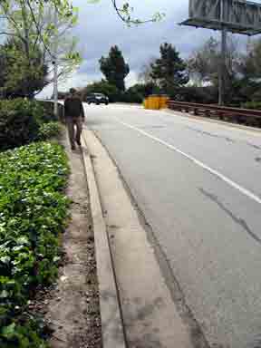
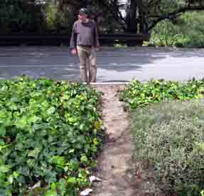
Paths on De la Cruz Blvd; route for Caltrain patrons:
These 3 photos show the paths and shoulder of the De la Cruz bridge over Caltrain. These are at the SE corner of the bridge, going to the CostCo parking lot from the bridge. One path is along the downramp. Another is from the shoulder to the CostCo parking lot. The speed limit here is 40 mph. Shoulder use is encouraged for pedestrians (see photo of top of the bridge) instead of the alternative of crossing the train tracks at-grade.
Paths along San Tomas; routes necessitated by hierarchical street patterns:
If there are ANY locations where staff deems walking on the paved shoulder of San Tomas to be unsafe, then simply inform the County staff to comply with the Master Plan by trimming shrubbery to create a dirt path. They can use a fraction of the $75,000 approved annually for the purpose. (Inform me if you need documentation of that Board approval.) Usually, the width between pavement and property line is 10 feet on expressway roads. Of this, two feet of width is sufficient for a path, judging from my observation of people walking on paths along portions of many expressways, De La Cruz paths, and a VTA document. This document states a width of 1'10" to 3' for "Single pedestrian through traffic". Source:
VTA's "Community Design and Transportation", approved Nov. 7, 2002 by the VTA Board, Figure 14 (chapter 4, page 19). This document is not uploaded to the Internet, but I have many quotes, relevant to the repeal of the walking ban, at this link:
http://moderntransit.org/expy/vta.html
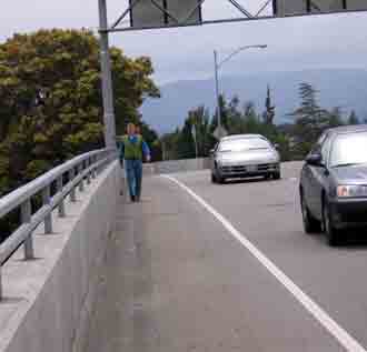
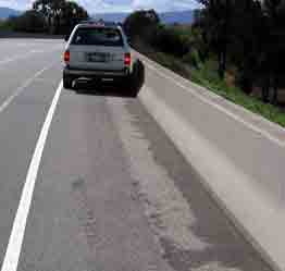
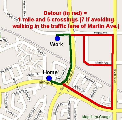
The San Tomas bridge over Caltrain already has a planned parallel path, the Creek Trail planned for 2007. As an interim, this bridge needs to be used by walkers (and is used , despite the prohibitory signs). When the parallel path is complete, guide signs should point the way, not prohibitory signs trying to prevent walking altogether. The County Expressway Master Plan, San Tomas section, page 8, states: "directional signage to parallel pedestrian facilities". The west side of the San Tomas bridge over Caltrain has a wider shoulder (shown with stopped SUV, below) than the De La Cruz shoulder pictured above. Furthermore, the San Tomas bridge has no sharp turns, such as on the De la Cruz bridge on-ramp from El Camino which limits the line-of-sight. Therefore, the shoulder of the San Tomas bridge is safer than that of the De la Cruz bridge. It is also much safer than the current alternative: a one mile walking detour with a half dozen intersection crossings and walking in the traffic lane of Martin Ave (see map). Yet, a $149 fine is imposed for using the route that is the safest.
 –
–
Why walking along both sides of the road (including San Tomas) improves safety:
The danger to a pedestrian crossing a road increases exponentially with road width. This means that expressway crossings, which are the widest arterial roads in the City, are, by far, the most dangerous to cross and that these crossings need to be minimized. That is why a path, shoulder or nearby parallel alternative route needs to be allowed for walking, and created where necessary, independently for both sides of the expressway, to prevent the situation of needing to cross the expressway twice.
While expressways are the most dangerous to cross, they are the safest arterial roads for going along, having less than a tenth of the intersections and driveways (for parking lots) of other arterial roads.
Greater efficiency for motorists:
Another reason for eliminating crossing the expressway twice is that, if it is not, it will unnecessarily slow down expressway traffic. The longest crosswalk crossing times are required for expressways because they are the widest of arterial roads. Therefore, preventing unnecessary pedestrian crossings will increase traffic flow rate on expressways.
Timing of prohibitory sign removal:
After prior repeal of both bicycle and pedestrian prohibitions by various cities, including by Santa Clara in 1991, the County highway engineers usually stonewalled for 6 months to one year before we forced sign removal. The most recent repeal example is Sunnyvale's repeal of the prohibition of walkers in 2003. The repeal was in full compliance with the County Expressway Master Plan. The County staff did not remove signs until one year later, in 2004, and then only because I went to the Board of Supervisors and informed them of staff's stonewalling. The Board, as I requested, by a unanimous vote, ordered their staff to remove those signs, which they then did, but taking 4 more weeks to do a 3-hour job. The point here is that after repeal, there is more than enough time to create dirt paths wherever City staff deems necessary.
The second point is that, unless there is repeal, County staff will continue stonewalling of implementing pedestrian safety features -- creation of paths -- as required by the County Expressway Master Plan. This requirement is without regard to whether or not pedestrians are allowed because, as I stated above, the signs do not eliminate pedestrians, only reduce their numbers. However, their excuse to avoid compliance, which is a stonewalling tactic, is the City's prohibition of pedestrians. In my opinion, they want to avoid compliance in order to continue miss-spending all of the $75,000 annual allocation for their own pet projects. Furthermore, as I only found out from VTA BPAC last year, there is a federal law that will require County staff to construct sidewalks in the future if pedestrians are allowed.
Conclusion:
I hope you would consider these points and support complete repeal of Resolution 5603. After repeal, staff and/or we, especially if working together, can easily achieve safety improvements as already required.
Sincerely
Akos Szoboszlay,
President
Modern Transit Society
http://moderntransit.org PO Box 5582, San Jose CA 95150 408-221-0694
Links:
Our San Tomas Expressway page shows example detour maps and lists violated policies:
http://moderntransit.org/expy/st.html
Link to maps for San Tomas, including a copy from the County Expressway Master Plan:
http://moderntransit.org/expy/santomas-map.html
Link to photos along San Tomas, including police giving a bicyclist (me) a ticket for being a pedestrian on the expressway while taking a photo:
http://moderntransit.org/fotos-santa-clara/fotos-santa-clara.html
Link to more photos: pedestrians and bicyclists on Highway 9 shoulders; notice that:
(a) the speed limit -- seen posted in two of the photos -- is the as same as for San Tomas Expressway; and
(b) pedestrians and bicyclists on shoulders use different positions relative to the edge of pavement and the shoulder line.
http://www.svcn.com/archives/saratoganews/04.12.00/hwy2-0015.html