The Free Market for Transportation Plan is published by the
Modern Transit Society (MTS) in 1991. It
was updated and formatted for the internet in December, 1998.
Printing instructions are also on this web page:
moderntransit.org/fmt/
The principle author is Akos Szoboszlay, (then Vice-President of MTS, now President). Major contributors are Mike Bullock (Director), Stanley Hart, and Al Spivak, P.E. (then President, now Vice-President).
MTS was founded in 1971, and has over 800 members. Its two main
chapters are in the South Bay of the San Francisco Bay Area (also
called Silicon Valley) and in Sacramento, the capital of California.
MTS was instrumental in the return of light rail transit in both
these areas. The MTS web site is
moderntransit.org
Alleviating concerns of potential opposition: page 3
Sources of roadway financing: page 4
Who benefits from road construction?: page 5
How to calculate the subsidy by a sales tax for freeways: page 5
Another low-cost way to increase roadway capacity: page 6
Modern Fare Collection: page 7
Protecting neighborhoods by using road fares: page 8
Other ways people benefit from the Plan: page 9
What is the alternative to "traffic mitigation" fees, developer fees for roads, etc.?: page 10
Conflicts over mandatory automobile accommodation: page 10
Huge city subsidies for autos, trucks: page 11
Charge pollution fees ... to those who pollute: page 12
What should road fares and pollution fees pay for?: page 13
Transportation modeling --a primer: page 14
How to equalize the parking subsidy: page 15
A way to eliminate subsidies: The Free Market Transportation Ordinance: page 16
Traditional vs. Hierarchical street patterns: page 17
How does the traditional system effect
automobile traffic flow,
specifically, capacity and travel time?: page
18
How does transit fit in to a traditional system?: page 18
This Plan details the legal and political steps to eliminate automobile subsidies, and to increase the efficiency of all transportation modes. It explains how to eliminate direct and indirect government subsidies, as well as government requirements for involuntary private subsidies. Included is a version of the plan written in legal form, as it would appear if it were a city ordinance. After enactment and evaluation, this would be a prototype for legislation to make similar changes at the state and county levels.
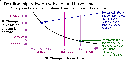
Automobile expenditures would be shifted from the general taxpayer to the automobile users. Fares for road usage and parking would be collected using non-stop, modern fare collection technology. FREEways would become FAREways. The use of free-market principles will benefit all transportation modes, including automobiles, and the economy in general. Sources for Road Financing (page 4) explains economic effects, and Modern Fare Collection (page 7) gives technical details. By using congestion pricing, the flow rate of automobiles would be greatly increased (see graph, below) and congestion eliminated.
The passage of this plan will eliminate requirements for the provision of parking, assessment districts for traffic mitigation, developer fees for roads, sales taxes for freeways and roads, and the myriad of subsidies (outlined in Huge City Subsidies for Autos, Trucks, page 11), which totals more than $4 per gallon of gas sold.
The elimination of laws forcing automobile accommodation and subsidies will allow land use to be transit/bicycle/pedestrian-oriented. No one would be forced to build transit-oriented development or to abolish parking spaces. This plan, if passed, would simply allow the possibility of transit, bicycle, and people oriented development, which today is prohibited almost everywhere. We believe that free market forces will naturally lean toward the types of development that occurred in the past, when public transit was privately owned and unsubsidized.
Pollution fees would be charged against air polluters, in amounts proportional to the pollution they produce.
Both pollution fees and road fares would pay for expenses and negative effects of the automobile. They should also substitute for general taxes (especially the sales tax) because, for decades, government subsidized the automobile and required land use that discourages transit, pedestrians, and bicycles (e.g., sprawl). The result of this government-required automobile-oriented development is that automobiles have an unfair competitive advantage. In order to attract private enterprise to again provide mass transit, this unfair advantage needs to be negated by government action to recover a profit from the automobile and truck transportation industry.
Everyone benefits by a Free Market for Transportation with the possible exception of oil, automobile, trucking, and highway/road construction interests (including highway engineers and Caltrans). But large groups of moneyed interests also benefit, making it easier for passage. (See Other ways people benefit from the Plan, page 9.)
One of the biggest selling points of the Plan is that it would even benefit those who insist on continued automobile commuting. This Plan would eliminate traffic congestion by using congestion pricing to achieve the optimal vehicle flow rate. At 40 mph, the capacity of a freeway is double that of stop-and-go, 10 mph traffic, and it takes 1/4 the travel time (see graph, below). This fact, while not widely known, is repeatedly found in highway engineering studies.
Even non-motorists would benefit by eliminating traffic congestion. Political pressure for more subsidies for more highway construction should end by people no longer stuck in traffic.
The above graph was generated empirically for a 55 mph speed limit. Higher speed limits will move the right segment of the curve to the right.
Sources: Highway Capacity Manual, Transportation Research Record #1005 (page 55), and other studies.
There has been great opposition to eliminating forced parking, low-density zoning, and outright subsidies. This opposition has been largely from citizen groups that do not want the negative effects of the automobile. Their concerns will be met by this plan, as follows:
Give property owners the power to control street parking fronting their property. In practice, many property owners would contract with a "parking management company" (similar to property management companies) and effectively rent out the spaces. For those people not owning cars, it equalizes the present street parking subsidy so that even they benefit.
There is no increase in traffic if all users of the development above the amount specified by current zoning travel to the development by means other than driving a car. This can be accomplished, for example, by charging a large fee on the property based on the average number of cars brought to work on a working day (or the average number above the current amount), and vary the fee to keep demand at the desired level. For high density residential development, implement a similar fee for each access by automobile, and vary the fee by time of day.
The only way to eliminate traffic congestion is by using demand-pricing fare collection, and the cheapest and most palatable form is by Automatic Vehicle Identification (AVI). AVI can easily be implemented on some of the lanes of any road, giving people the option of paying for road usage either by their time or by their pocketbook. (See Modern Fare Collection, page 7.)
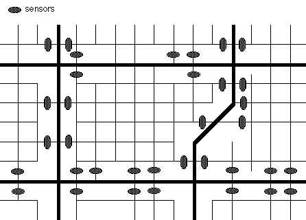
Neighborhood protection is assured by using zone charging (using AVI technology). Sensors are placed to charge a premium to deter traffic from using neighborhood streets. Those who have a neighborhood destination are not charged (if they stay a while, or leave the same way). See illustration, page 8. The present system uses 4-way stop signs, traffic barriers, winding street patterns and other impediments and is extremely inefficient. It is counter-productive, as it discourages bicycle, walking and transit usage more than it does car usage. The monies collected from driving through neighborhoods would be divided among the dwelling units of the neighborhood to decrease the property tax of those who must bear the noise and air pollution (or compensate loss of property rental value).
1) give or increase welfare checks equal to the value of the auto subsidy that would be removed. This gives freedom of choice to the poor person, further benefiting him/her. Many will use the money for other than motoring purposes, resulting in a decrease in air and noise pollution, and in congestion. This is a social benefit for all people over the current system of giving out automobile subsidies only to people choosing to use automobiles.2) The poorest, who cannot afford a car, can even less afford to pay the regressive sales tax for freeways and property taxes (through rents) that pay for most automobile-related expenditures. The true poor would definitely benefit. As automobile transportation costs become paid by direct users, taxes that today pay for these costs should be reduced in an equal and balanced manner. An auto non-user substantially benefits. An auto user would come out about even (while some out-of-pocket costs would be higher, efficiency would also increase, such as eliminating most congestion, or lack of parking spaces).
They would wait less than they do today. By using demand pricing, the automobile capacity of roads increases, thus reducing congestion for all traffic lanes in the corridor (including "free" lanes).
By charging market price for parking, the demand for parking spaces would be reduced to assure availability of some empty parking spaces. An efficient method for charging for parking is detailed in How to equalize the parking subsidy. It is extremely important to eliminate "free" parking. Several empirical studies show that solo-driver commuting would be reduced by 20% or more if drivers had to pay for their own parking. There is no incentive for employers to charge for parking (thus leaving empty parking spaces) unless the land can legally be used for other purposes.
The present parking subsidy is an employer-provided benefit with a monetary value. But, only employees who drive cars are given this benefit. The benefit needs to be equalized for all employees. In essence, the parking fees collected need to be re-distributed to all employees as a bonus in their pay.
There are a number of methods for financing roads. They are much more than just different accounting schemes. Each financing method has an effect on people's transportation decisions. The financing method greatly affects land use, traffic congestion, and the environment.
Payers are the people paying for a product, for example, a freeway or a freeway widening. Beneficiaries are the people directly benefiting from a product. For freeways, it's usually peak-direction car commuters. The correlation measures how well the two groups of people match. (If the two groups are comprised of the same people, the correlation is defined as one. If there is no relationship between the two groups, the correlation is zero.)
A fare charges only those people who are direct beneficiaries of the road building or widening. A fare has the highest correlation between payer and beneficiary. In the past, "toll" collection has been inconvenient and has involved high overhead. However, modern technology has changed that. New methods of fare collection do not require vehicles to stop or even slow down, and they eliminate toll-taker labor. Lower rates can be charged non-peak-direction commuters. Because peak traffic flow occurs at about 40 mph, varying the fare by time to control traffic flow will efficiently increase road carrying capacity. This is called demand pricing. There is no wasting of time, as with on-ramp metering and bumper-to-bumper traffic. Fare collection is legal under state law for privately-owned roads. An act of the legislature (as was passed for Orange County) may be required for publicly-owned roads.
The last three methods of financing tax everyone to support a particular group: car-commuting workers, and provide no disincentive for car commuting. On the contrary, this outright subsidy provides an incentive for increased --and greater distance-- car commuting. Why? Transportation modeling --a primer (page 14) explains how a 29% decrease in travel time (resulting from road construction) will double the demand on the roadway if there is no disincentive to usage. This is the consequence of general-sales-tax and property-tax financing.
|
|
|
|
demand pricing |
meets free market principles; |
|
|
|
|
charges less to long distance car commuters per mile of commute |
|
|
|
does not differentiate between peak and off-peak |
|
|
|
penalizes those who keep a car but take transit or bicycle to work |
|
|
actually increases car commuting |
penalizes those who take transit or who bicycle to the developments, including home buyers who don't own a car. |
|
|
actually increases car commuting |
penalizes those who take transit or who bicycle, including those who don't own a car. |
|
|
actually increases car commuting |
penalizes those who take transit or who bicycle, including those who don't own a car. |
Proclamations by the highway lobby that everyone benefits by a general subsidy of roads is not supported by facts. They completely ignore fundamental economics, regardless of whether they subscribe to socialistic or to free market principles. They ignore the fact that a road may simply be uneconomical. No economic analysis is done, whether by an Environmental Impact Statement, by Caltrans (see quote), or by an independent research group. The decision regarding which roads to build is usually based on political strength, rather than economics.
However, there is already a mechanism in place for determining whether a new road or road widening is economical, without adding to bureaucracy. This method is the free market. It separates politics from economics. The free market would determine if it is truly economical to build or widen roads, but the free market can only work if there is a high correlation between payer and beneficiary. In a free market, price regulates demand of any product or service.
In a free market, the consumer's dollar constitutes his vote --a vote with more clout than the ballot box. Hence, bringing roads into the framework of American fiscal principles gives the transport consumer new strength and new decision making power which he thus far has lacked.
Providing a "free" service will increase the demand for that service until saturation (i.e., congestion, waiting) is reached. This principle applies to use of a sales tax to build or widen freeways. Because there is no correlation between use and perceivable cost, traffic congestion will inevitably return and air pollution will increase.
There are two distinct situations for constructing or widening roads:
Case 1) Increasing the capacity of existing roads by building parallel roads or increasing the number of lanes.
If it weren't for rush hour traffic, there rarely would be construction to increase capacity. Adding capacity only benefits car commuters, and usually only in the peak direction. For example, Rt. 237 in Santa Clara County had 1/6 the vehicle-per-hour flow in the reverse commute direction than in the peak direction. The peak direction was, and still is, bumper-to-bumper (at capacity), despite adding lanes. This means the traffic in the non-peak direction was 1/6 of the capacity of the road, and the off-peak traffic flow is even less. Clearly, only peak-direction car commuters benefited from adding the lanes.
Case 2) Building a road into a newly-developed area.
Only direct users of roads to a development (the beneficiaries) should pay for them and for road widenings elsewhere that are due to the development.Developer fees for road financing are actually counter-productive. They encourage greater car usage to the development instead of encouraging people to take alternatives to driving. This also increases traffic congestion and air pollution for the region. In contrast, by using Modern Fare Collection (page 7), price becomes the natural disincentive to usage.
While the subsidy to transit is often quoted as so much per passenger-trip, the subsidy for cars has been routinely ignored by sales tax backers. Yet, it is easy to calculate how much an average car trip would be subsidized by sales taxes because case 1 (above) is applicable.
For Santa Clara County, the direct subsidy paid by the sales tax is $5 per car-trip. If the users actually had to pay the $10 per day round-trip fee, so many people would have chosen alternatives to solo-driving that the freeway widenings would not have been needed. Therefore, these freeway constructions were economic boondoggles. (The gas tax paid by these commuters is insignificant, averaging less than twenty cents per day).
The economic benefits of the Free Market for Transportation Plan become more obvious when considering a hypothetical analogy:
1) long distance usage will greatly increase
2) most privately-owned long distance carriers will eventually go
bankrupt (as did many privately-owned public transit companies in the
past), even if they provide superior service or have lower operating
expenses.
3) long-distance capacity will have to be greatly increased due to the increase in demand.
4) because there is no monetary incentive to use the system off-peak rather than at peak periods, people attempting to use the system at peak periods would not be able to get through unless they spent a lot of time redialing.
5) the cost to society of providing the "free" long distance service would be greater than the benefit to society.
6) government efforts to discourage long-distance calling by encouraging letter-writing will have negligible effect: the "free" calling has the same lure as "free"ways.
7) because long distance telephone service is not polluting, the analogy does not hold for the increase in air and noise pollution caused by a sales tax for freeways and roads.
Define roadway capacity in terms of moving people, instead of moving vehicles. The capacity of light rail transit is proportional to the average speed (up to a two-minute headway, or the capacity of a 20-lane freeway). For streets and roads with light rail transit lines, the cheapest roadway capacity increase is realized by increasing overall speed, by giving signal pre-emption and not allowing automobiles to use the tracks. Under these conditions, light rail transit speeds approach that of a subway system.
The city of Zurich, Switzerland demonstrates this optimum use of light rail transit. Auto traffic is minimally impacted by signal pre-emption for light rail vehicles because light rail only needs about 20 seconds of signal time to get through an intersection, and comes once every 2 to 6 minutes. These 20 seconds are also used by automobiles traveling parallel to the light rail. Signal timing can still be set to give cross traffic most of the green, if desired. In any case, there would be a much longer wait for cross traffic if all the people in the light rail switched to automobiles. This demonstrates another advantage of light rail vehicles: it groups people together in the time domain, takes less time to cross intersections, and can avoid costly grade separations that occurs with a distributed flow of automobiles such as for freeways.
The City Council of Zurich adopted the following policy in 1975:
"In accordance with the city council's repeatedly stated wish to give priority to public transport when weighing various transport interests, the city departments are hereby instructed in principle to give preferential treatment to public transport. Moreover, reasonable provision must be made for the needs of pedestrians, disabled people, bicyclists and delivery vehicles. The environment, the quality of life and the city's residential areas and the townscape must also be taken into account."
A small plastic case, called a "tag" (shown below) either attaches to the vehicle, or is placed on the dashboard. The tag contains information in an electronic memory that is transmitted to roadside "readers" using radio frequencies. There are two methods:
Both methods should be used, to give people a choice.
The readers do not have to charge the same rate to all vehicles. Trucks and buses should be charged more. If a new lane were constructed, users of that lane should be charged for the lane construction. Existing carpool [HOV] lanes should be re-designated as "Fast Lanes" (now called "HOT" Lanes) and they should charge a premium rate to all vehicles.
Most important, the fare per mile can frequently change to keep traffic flowing at an optimum speed, thus eliminating congestion. The current rate would always be displayed by variable signs (as is now done on bus destination signs). In fact, computers will have all the information to control traffic flow by using congestion pricing, also called demand pricing. Computers can also signal a stall or an accident.
Webster's defines "fare" as "the sum paid or due for transportation". In contrast, a "toll" is a "tax imposed for some privilege or other consideration". We think "fareway" is the appropriate alternative to "freeway".
Some tags, called "read-write" tags, are both readable and modifiable. Like any pre-pay ticket, privacy is assured. Unlike phone cards or BART ticketing, the tag is read and modified on the go -just by passing by instead of inserting. The tag is completely re-usable. By inserting into an off-line pay machine, the value can be increased upon inserting money or a credit or bank card. Unlike "read-only" tags, these "read-write" tags contain a long-life lithium battery.
What if the state requires all vehicles to have permanent tags in the future? Because the tags contain license plate information (information that is public), because tags do not disclose who is contacted (unlike the telephone utility bill), because anonymous travel alternatives exist (transit, bicycle, taxi or car-rental), and because driving is a privilege, rather than a right, privacy is not abridged.
Two methods exist for catching fare evaders:
1) Automatic method: modify recently-installed systems for automatically "ticketing" speeding vehicles by mail (e.g., City of Campbell). Fare-evaders have their "picture" taken. (Fare-evaders are vehicles delinquent on their utility bill, without tags or with zero-value "read-write" tags.)2) Roving inspector method: The light rail and trolley fare collection in Sacramento, San Diego, and Santa Clara Counties all use a system of roving inspectors who check tickets randomly. (MUNI is estimated to save over $1 million a year by switching to this system.) This system has been used for decades in Europe and Japan. The systems actually make a profit on people who get caught evading the fare. The fine for fare evasion, payable on the spot, is typically 50 times the cost of the fare.
Catching fare evaders on fareways is even easier. For transit, a roving inspector must check the tickets of all transit riders that he passes; but for fareways, a portable computer displays if fare evasion is occurring, and fare-evaders can be targeted without inconvenience to fare-payers.
Yes. This technology is called Automatic Vehicle Identification (AVI) or Radio Frequency Identification (RDIF). It not only is used in factories for manufacturing, but is being used on roads. Dallas, Texas recently installed AVI for collecting road fares. Golden Gate Transit uses it to identify buses crossing the Golden Gate Bridge. [Update: this technology has successfully been implemented in Riverside and San Diego Counties of California.]
The price of electronics has dramatically decreased while capabilities have increased. The cost of implementing Modern Fare Collection is more than offset by the increased capacity that results when demand pricing is used to keep traffic flowing at an optimum flow rate. Even greater savings are gained by the increased efficiency of the transportation system, including separation of politics from economics, so that economic viability, rather than political clout, will be the criterion for road construction.
No. When fare collection is initially implemented, most cars can simply avoid tags because:
1) most freeways have alternative routes,2) streets can use zone charging. Charging cars a premium for going through neighborhoods does not require sensing devices everywhere (see figure), and
3) arterials (major thoroughfares) can be the last to require tags.
Neighborhoods are protected from drivers attempting to avoid arterials (shown as thick lines) by zone charging. Sensors (shown as ovals) are placed to charge a premium to deter traffic from using neighborhood streets (shown as thin lines). Those who have a neighborhood destination are not charged. This is if they stay a specified minimum time, or leave by the same route.
This method also increases efficiency of neighborhood traffic. Most four-way stops signs are placed not for safety but for another purpose. The purpose is to deliberately cause inefficiency to drivers to discourage them from using neighborhood streets. Other inefficiencies currently used are "no right turn" signs, closing of streets to through traffic, and winding, random and intermittent street patterns. The deliberate inefficiencies also discourage bicycling and walking. Four-way stop signs greatly slow bicycling. Pedestrians are effected by increasing the walking distance. This also decreases transit patronage.
These inefficiencies can now be eliminated without adding to neighborhood car traffic by use of zone charging. Not every entrance to the neighborhood needs a sensor. For example, the some streets below do not have sensors where leaving them out would not encourage a driver to shortcut through the neighborhood.
The implementation would eliminate the following:
Laws force the providing of parking based on floor area, number of bedrooms (for apartment complexes) and tables (for restaurants). These laws force all consumers to pay higher prices to subsidize automombile transportation, and encourage greater auto usage. Studies have shown that transit usage would be tripled in many regions by eliminating laws that force the providing of parking.
Most low-density zoning is established solely for traffic mitigation purposes. Silicon Valley is an example, with the industrial area density at .35 FAR (Floor Area Ratio). This means that a six-story building is required to occupy land that is 18 times greater than that required for the building itself. The excess land can be legally used only for parking lots and landscaping. It eliminates efficient, compact development. It makes the area extremely difficult for transit to serve, increases distances (making it much harder for bicyclists and pedestrians), and takes up open space land. Considering the price of land, the excess land is also very expensive for the landowner. The land is wasted.
Another example of low density zoning is San Jose's prohibition of "granny" homes. While this law was made to minimize on-street parking, it damages transit and brings greater pressure to use open space land. It also exacerbates the severe housing shortage.
These are counter-productive because they encourage greater automobile usage. They are also unfair to non-car users, who must subsidize lane construction, interchanges, parking lots, etc.
These are very damaging to transit because:
The potential transit user is not given the free-market choice of either using this increase in cost to pay for automobile transportation, or to pay for transit. These costs are passed on to the development residents through higher rents (or purchase prices); and to employees working at the development through wages reduced from what the companies could pay if their facility costs were lower. Even if they prefer to use the money for transit, they still are forced to provide for automobiles, which compete with transit.
The potential transit user may never use transit to/from such development (either residential or industrial) because:
(a) the money he/she has earmarked for transit fares has instead gone to pay for the freeway, local roads and parking lots.(b) the competing automobile facilities are already in place. For example, the freeway's usage cost appears to be zero because he/she already paid for it (albeit against his/her free will).
(c) any transit service in such an area will be infrequent (more waiting) and spread thin (more walking). Moreover, because transit farebox revenue is proportional to the number of people taking transit, more subsidy will be required.
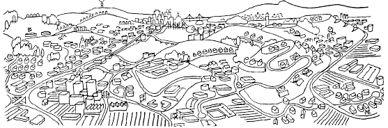
Open space does not harm transit. In the past, development often clustered around transit stations. Developers sometimes supplied guideway transit to their developments (including some in the East Bay and San Francisco). Unlike today, those developers were not required to put in roads and parking lots, and forced to spread out the buildings so that transit users could not walk to them from the station.
Without using more open space, existing development will gradually become transit-friendly as laws for automobile accommodation are repealed. These laws include FAR (Floor Area Ratio) limits, max. dwelling unit and similar low density zoning, mandated parking lots, and road construction (unless such construction is 100% user paid). Transit-friendly development neither takes public money, nor interferes with private property rights.
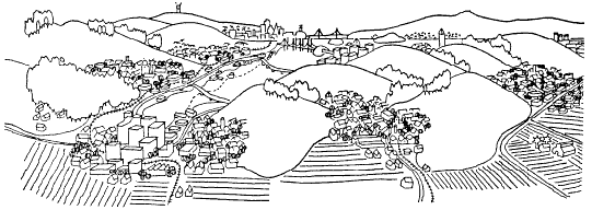
Sprawl harms transit. It is encouraged by automobile subsidies and enforced by government regulations.
Graphics courtesy of Greenbelt Alliance
The best way to charge users of a new development for freeways and local roads is to charge only the freeway or road users, rather than all users of the development. This is accomplished by modern technology. If a freeway is truly economical to build, and no public money is available, private enterprise will build the freeway ("fareway") at a profit, just as transit systems once financed their systems from the farebox. This also holds true for lane widenings and new road construction. If the developer wants a road to his proposed development, it is best to tell him "if you want it, build it at your expense", rather than "you must build the road". By not requiring road construction, the developer may construct a guideway transit line, as shown by history. Many streetcar companies constructed guideway transit into new developments (preceding it with land purchases).
The full costs of accommodating the automobile needs to be voluntarily transferred to automobile users. This is accomplished by repealing laws that force automobile accommodation. For example, it would be in the interest of an employer to pay employees not to drive to work if some of the parking lot space is allowed to be productively used.
The root cause of difficulties for transit is the lack of a free-market for competing transportation. Returning to fundamental free market principles is the most effective way of helping transit. There are beneficial side effects, including cleaner air, less noise, and a safer city.
There has been a never-ending battle of companies wanting to build higher buildings, reduce parking lots, and not wanting to pay for "traffic mitigation". They range from large developers to small restaurants (who must provide one parking space per restaurant table). They do not have the correct arguments for achieving their goal. They typically use a "hardship" argument that is not convincing. But their goals are also the goals of transit advocates, and should be the goals of all environmentalists. They need to argue that there is a hardship on transit users, bicyclists and pedestrians. They need to declare that their automobile accommodation will result in more air pollution, that it is inconsistent with the free market principles, and that it goes against transportation policies that encourage people to take alternatives to the automobile.
For the car user, it makes no difference who pays the subsidy to make his car usage artificially cheap: the general taxpayer, or businesses that are required to do so by government.
"Campbell officials will [also] require Trammel Crow Company to pay for ways to ease traffic. ... Prometheus Development Company, which built two office complexes on Hamilton [Avenue] on the east side of Highway 17, spent $7 million on new traffic signals, turn lanes, wider streets, signal synchronization and highway ramp realignments."
The $7 million automobile subsidy paid for by this developer would have paid for about half a mile of light rail transit -transit that would have carried many times more people than the roadway improvements per dollar invested. Given the option, the developers could move far more people by light rail than by accommodating and subsidizing the automobile. In addition, they would have gotten greater value from the land by reducing parking lot size and using higher density, advantages which in turn, would have further enhanced light rail transit patronage and value.
Cities provide services for motorists and truckers; but the payment received for providing these services have not been covered by user payments. What are these services and how much do they cost? A study for the City of Pasadena is probably typical for most cities.
The Pasadena Police Department is organized into a number of special "details" for control of the automobile/truck population. These include the motorcycle patrol, details for auto theft, manslaughter, and parking enforcement. The largest category is the patrol personnel whose duties include traffic control, accident investigation, auto theft, etc. An analysis of personnel time and salaries indicates that 40% of Police Department costs are incurred in auto-related activities.
Automobile/truck accidents, fires, and garage fires comprise about 14% of Fire Department alarms. 16.4% of Paramedic calls are automobile-related. The City Prosecutor estimates that about one-third of his staff time is occupied with auto/truck cases.
The Public Works Department includes the offices of the City Engineer, the Traffic Engineer, the Road Department, Sewers, Sanitation and others. Each office is budgeted separately; thus auto-related costs are easily segregated. Capital and debt service expenditures are identified readily as well.
Staff studies have recently determined the proportion of administrative costs to be 13.45%. This proportion was added to the total of auto-related expenditures.
Since the Pasadena study included all costs associated with streets it is appropriate to subtract an amount for the estimated annual cost of constructing and maintaining an alternative system for public service vehicle access - fire and police protection, garbage collection, freight delivery, etc.
Motorist contributions originate from two principal sources - the fuel and the in-lieu taxes - and a third, much smaller source, the combined traffic/ parking fines, off-road vehicle fees and other special fees.
The table lists results of this allocation of City expenditures for FY 1982-1983. (The 1983 population was 123,000.) Depending on the nature and the relevance of the available records (which, of course, were not intended for this purpose) these figures are variously accurate, but they are always conservative.
The magnitude of the shortfall (or subsidy), when county government shortfalls are added, is probably equivalent to 40 to 50 cents per gallon of fuel. If Pasadena is not atypical, the nationwide subsidy derived from local government is $60 billion annually or about 2% of the gross national product.
Nor is this all; there are huge subsidies for free parking, corporate automobiles and tax deductible perquisites furnished by businesses. The total must amount to hundreds of billions annually; $2000 to $5000 per vehicle. Additional costs to society include lost property taxes when land is converted to freeways and the damage resulting from pollution.
Our love affair with the automobile --it's not passion, but cash, that plays the critical role.
A more detailed and technical web page by Stanley Hart is also available.
|
Department |
Portion of department's auto-related costs |
% of department budget |
|
Police Dept. |
$4,683,300 |
39.9% |
|
Fire Dept. |
944,900 |
13.8% |
|
Paramedics |
142,000 |
16.4% |
|
Public Works |
5,303,000 |
varies |
|
Debt Service |
555,600 |
varies |
|
Capital Projects |
2,097,300 |
varies |
|
Subtotal |
13,726,500 |
|
|
Administrative |
1,846,200 |
13.45% |
|
Subtotal |
15,572,700 |
|
|
Public Service |
(-)166,000 |
|
|
Motorist contribution |
(-)3,723,000 |
|
|
Shortfall (1982-1983) |
$11,683,700 |
The ideal method to discourage air pollution is to charge air polluters an amount proportional to the pollution they produce. There are different factors in automobile and truck usage that relate to the amount of pollution produced, and can be approximated by different charging methods.
Vehicle ownership. Owning a vehicle has some constant pollutants, such as CFCs. Significantly raising the vehicle registration fee would especially discourage clunker cars (the least safe) and teenagers from driving.
Emissions fee. Measure the pollutants from an automobile, similar to what is presently done, but on a yearly basis. Multiply by the vehicle miles travelled (VMT) of that vehicle by using the odometer. Do not exclude trucks, buses or motorcycles.
Vehicle trips. Just turning on the engine causes much of the air pollution. A charge for vehicle trips is accomplished by a counter (with a 10 minute timer so that re-starting engines would not be counted). The annual emissions inspection would record the count.
Fuel tax. In California, the petroleum industry produces more hazardous waste then all other industries combined. (Source: Citizens for a Better Environment). A fuel tax encourages conservation and is one of the easiest to administer.
Noise pollution. Measure decibels for trucks, motorcycles, buses and vehicles with snow tires. Noise above a certain amount, measured while traveling at a certain minimum speed (for tire noise), and accelerating from a stop to a minimum speed (for engine noise), should be charged a rate times miles driven.
Rubber dust. About 4 pounds per car per year (average) are removed from tires as "rubber dust". This is, in fact, a toxic petroleum product that also creates a yet-unresolved environmental disposal problem. Charge a fee on tires based on tire width, vehicle weight, and/or other criteria. Do not exclude trucks or buses.
1. Pay for auto and truck expenses that are now subsidized from general taxes. See Huge city subsidies for autos, trucks (page 11). This is accomplished by the Free Market for Transportation Ordinance (page 16). To be politically viable, taxes that currently pay for subsidies must be lowered in an equal and balanced manner.
2. Charge an equitable property tax for road-occupied land. While railroads are often the largest taxpayers in counties, freeways, which take up many times more land, don't pay a cent. Highways should pay property taxes at the industrial rate, since transportation is an industry. Airports also should pay the same tax, since their present exemption creates unfair competition rail service, as well as additional tax burden for other business and residential property. There must be an equivalent lowering of other property taxes in the region, so that there is no net change in total taxes paid.
3. Pay for local air and noise pollution: Cars driving through a neighborhood should pay for the lowering of property taxes of that neighborhood. Freeways and major roads should pay in order to lower the property taxes of affected property.
4. Pay for road maintenance. (Note: all new roads and lane additions should be 100% paid for by direct users after points 1,2,3 and 7 have been satisfied).
5. Pay for regional air pollution damage. Lower property taxes for each dwelling unit in the polluted region. Make direct payments for agricultural losses and forest damage, including parks.
6. In combination with (3) above, pay additional compensation for local air and noise pollution for each dwelling unit near freeways and major roads. This should be done by formula.
7. Substitute for some general taxes (especially the sales tax) because:
a. For decades, government required land use that discourages transit, pedestrians, and bicycles (e.g., sprawl). The result of this government-required automobile-oriented development is that automobiles have an unfair competitive advantage. In order to attract private enterprise to again provide mass transit, this unfair advantage needs to be negated by charging the automobile and truck transportation industry in a way that benefits all citizens.b. The above points (1-6) merely compensate for some effects of the automobile. Travel by automobile and truck should be discouraged for global and local environmental reasons, for the safety of pedestrians and bicyclists, and for resource conservation. Anything that is taxed is discouraged. A sales tax is regressive and discourages purchases and sales. It is no different than an internal tariff. Therefore, replacement of the state sales tax with monies generated by road fares and pollution fees would be a logical decision.
c. Automobiles unfairly discourage the competition. Some potential bicyclists don't want to breathe in exhaust fumes (smog concentrate) while exercising. Many are afraid of being hit by autos. Traffic roar discourages waiting for transit. "Bus shelters" often fill with exhaust.
d. While automobile and trucking interests will argue that it is unfair to tax their industry more than others, the fact is that they have been subsidized for decades, and have paid nothing for the use of the land occupied by their roads. The tax would not even pay back the damage, including hostile takeovers and liquidations of transit systems by automobile interests in all major California cities except San Francisco.
The purpose of transportation modeling is to give decision makers a clear picture of the consequences of each transportation project being considered. The model's primary results are the number of users on the project and the number of users on existing (primarily parallel) routes. Other factors, like air and noise pollution, can be determined by knowing the number of users (primarily commuters) for the type of project.
vehicles = k / time / time
where k = trip generation characteristic.
Looking at ratios instead of number of vehicles and minutes, this becomes
%_change_in_vehicles = 1/(%_change_in_travel_time)2
Note: Transit patronage uses the same equations. Substitute "transit patronage" for "vehicle" in the equations.
1) Divide the geographical region into zones.2) Compute, for each zone, the trip-generating characteristics, such as the number of trip starting points and the trip ending points.
3) Compute, for all pairs of zones, the number of trips between them. This produces the trip table.
4) Assign all trips to the various car routes and transit routes.
The modeling and study of a number of projects for one transportation corridor is called an Alternatives Analysis. A particular transportation corridor might have several potential projects. Examples are light rail transit, 4-lane freeway, 8-lane freeway, or an expressway. A no build alternative is also studied because it is a requirement of federal funding. The last three steps must be done for each transportation alternative, including the no build alternative.
The trip table will be different for each alternative. For example, a freeway alternative will not have the same trip table as the no build case, for two reasons.
First, a change in transportation facilities has an effect on land use. This will change the trip table.Second, the project that gets built will have an effect on people's decisions about where they will work and live. This will also change the trip table.
A simple example of the effect on land use is the fact that the city of San Jose will "trigger" the development of 12,000 homes in Coyote and Almaden Valleys upon completion of Fwy. 85, financed by the sales tax. [Update: the freeway and housing are now built]. The added commuters will have a significant impact on the freeway which caused the houses to be built. One car from each of the 12,000 homes represents 111% of the two-hour carrying capacity of a 6 lane freeway in the peak direction.
People decide where they will work and live, in part, based on what transportation facilities exist. More freeways will encourage people to live further from work. For example, most people in Coyote Valley (in residential south San Jose) will not now consider taking a job in Palo Alto (a north county job center). At present, it is a 25 mile commute via bumper-to-bumper traffic on freeways 101 or 280. The new Fwy. 85 will significantly increase the number of these commuters. This is because a new freeway would initially decrease the travel time. Travel time and cost, but not distance, are what people use in evaluating whether a commute is worthwhile. As the congestion returns and increases travel time, the incentive for long distance commuting also will decrease. (This is similar to the concept of equilibrium in chemistry.) But the damage will have been done; an increase in the average commute trip length. [Update: just two years after constructing Freeway 85, traffic in the corridor is worse than it ever has been, according to news reports. Constructing the freeway and its induced sprawl developments actually made commuting worse. Furthermore, the promise of "traffic relief" by the special interests, in order to get the public to pass their proposed sales tax to construct the freeway, is now proven false.]
The calculations to compute the trip table are often referred to as the Gravity Model (see curve above). It states that the number of trips between two zones is inversely proportional to the square of the time that it takes to travel between those zones. For example, if travel time is reduced to half by constructing a new project, then the number of trips (or cars for the case of car commuting) would increase by four times (assuming the price stays the same). In order to double the number of trips, the travel time would only need to be reduced by 29%.
Present and predicted shortages of transportation facilities require strategies to reduce the number of cars on the road at rush hour. An EPA study has concluded that "free parking" is, on the average, worth the same as commute gasoline and that its elimination would reduce commute car traffic by 20%. [Update: newer set of studies shows 25% traffic reduction]. However, workers may be reluctant to favor its removal. A better approach, then, is to give each worker the option of converting his own parking lot benefit into money.
We suggest that companies adopt programs whereby employees pay for their car parking only in proportion to the amount that they use the parking and that all employees receive an increase in compensation so that no employee comes out behind. Such a program requires that equitable and convenient methods of pricing, collection and distribution be established.
Calculating the cost of parking per year is an easy procedure. The cost of parking is the value of the parking facility (land value plus improvement cost) multiplied by the current prevailing interest rate, added to the yearly parking maintenance cost. The resulting price per day per parked car would have to be adjusted periodically. For example, if the average number of cars being parked were to decrease, the price would have to increase unless the parking lot size could be reduced.
While the most straightforward method of collection would be ticket dispensing and coin operated gates as is commonly used in airport parking lots, we would like to suggest an alternative. First, every employee would select the days of the week for which he would like to commit himself to the use of the parking lot. Then, employees would be issued a plastic card which would show their selected days, their name, and their employee number. This card could then be placed on the dashboard of a vehicle to indicate its authorization to be parked in the employee parking lot. If an employee decided to drive on a day not indicated on his card, the employee would buy a one-day pass which he would date and set on the dashboard next to the plastic card. The one day pass could be purchased at any time before the company's "daily spot check" is made. In fact, employees could buy them days or even weeks ahead if the need was anticipated. No cash would change hands during the purchase of these passes. The employee would simply indicate his employee number (show his badge) to the person (guards or secretaries, for example) dispensing the passes. The pass dispenser would write the employee number on a list which would then be given to the payroll department. The employee's paycheck would then show a parking lot charge for each of the employee's normal committed parking days and for each special one day pass purchased during the designated pay period.
The distribution of these funds would be straightforward. The total worth of the parking facility for a pay period would be divided equally among all employees and would appear in their paychecks as a "parking lot rebate". The company could then add to each paycheck an amount, identified as "bonus," so that even employees that parked everyday would break even under the arrangement.
This program has several advantages. It would require a very minimal effort on the part of the employee who drives every day and who gains no monetary advantage. He must only keep his plastic card on the dashboard of his car. Other employees, who would receive a monetary advantage, would certainly be pleased. It is the honest removal of a present incentive to drive. It would reduce traffic.
Assume the following hypothetical company conditions:
Then, the cost to park per day =
[ ($250000 + $50000) (.15) + $500) ] / [ (90) (260) ] = $1.94
The parking lot rebate (per week) =
[ ($250000 + $50000) (.15) + $500 ] / [ (100) (52) ] = $8.75
The bonus (per week) =
(5) ($1.94) - $8.75 = $0.95
Therefore a person who rode transit everyday would gain $9.70 a week. A person that drove three times a week would gain $3.88 a week. [This article was written in 1981, so the figures should not be taken as today's costs. Of course, the equations do not change. -Editor]. A person that continued to drive everyday would break even. The "bonus" would cost our hypothetical company $95.00 per week. If zoning laws are changed so parking is not required, then theoretically it would not cost the company anything because $95 per week would be saved by reducing parking and using the land for something productive.
Mike Bullock is currently working to have VTA implement this plan.
Footnote 1: The EPA report is DOT/ESPA/DPB-50180116.
1. Obtain support of environmental, business, and civic groups for a city policy to eliminate subsidies to automobiles and trucks. Explain how all travel modes will benefit, even people who choose to continue traveling by car.
2. Approach an environmentally conscious city and ask the City Council to pass the following:
It is the policy of the City of ____________ to not subsidize, require the subsidy of, nor support the subsidy of, automobile and trucks. The City departments are directed to write draft plans and draft revised ordinances for implementing this policy.
3. After this policy has been approved, it should be easier to pass the Free Market Transportation Ordinance (below) or equivalent. Actually, a number of ordinances would need to be changed so that they do not contradict this one.
1. General principle and general taxes
The City of ____________________ (Government) shall not require a person, other than those who either own a motor vehicle or purchase a motor vehicle product or service (User), to provide for motor vehicles1, either directly, indirectly, or through taxation.2 Only public money from accounts that are wholly obtained from User(s) can be used to provide for motor vehicles.3 Accounts that provided for both motor vehicles and other sources will continue to fund other sources.4 Any monies that remain in the accounts which are prevented from being spent by this ordinance, including interest, shall be returned to the taxpayers.5 "Service" used herein is not to be construed as contracting for the provision of transportation (e.g., delivery fees, bus fares)6, but does include fares for road usage7. "Provide for motor vehicles" includes, but is not restricted to, parking for motor vehicle(s), roads for motor vehicles, any other facility8 for motor vehicles, and all expenses of Government that would not occur or would become unnecessary if motor vehicles do not exist9.
2. Accommodation on private property
With respect to private property owners10 or businesses in general, Government shall not require the providing, known herein as Accommodation, of parking for motor vehicle(s), roads for motor vehicles11, or any other facility for motor vehicles, either directly, indirectly, or through taxation. Government shall not have an imposition or increase of payments or imposition or change in requirements of any kind if Accommodation is not met, or is less than any amount.12
3. Low density zoning (regional accommodation)
With respect to private property for an area that is not zoned for agriculture or open space13, Government shall not restrict the use14 of property for the purpose of traffic mitigation15 or motor vehicle parking mitigation16, except that Government may impose restrictions of access of motor vehicles to property, including but not limited to: specifying a maximum number of parking spaces; specifying a maximum number of vehicles using the property; and/or imposing of fees for access of each motor vehicle, an average of motor vehicles accessing said property, and/or on each motor vehicle or average above a certain amount.17
With respect to the aforementioned property, Government shall not: use Floor Area Ratio18 or building volumes to restrict the use of property; regulate building dimensions for the purpose of traffic mitigation or motor vehicle parking mitigation, excluding regulation for building height and/or recessing buildings from surrounding property or naturally occurring object; or regulate the number of buildings nor the number of dwelling units, either per land area or per property lot, unless the specified number of buildings or dwelling units is zero in accordance with other laws.19
4. Ability to charge for accommodation
Anyone providing Accommodation at their own free will is free to charge direct Users of the Accommodation, without Government interference of the price or terms of contract, subject to other laws regulating the free market.20 Government providing Accommodation can charge direct Users of the Accommodation.21 Government is encouraged to charge so that, as a minimum, the cost of the Accommodation is recovered from its direct Users.
5. Fares on existing roads
With respect to any road that it owns, Government may charge Users fares for road usage. Government is encouraged to charge market value, including demand pricing, as determined by common business practices.
6. Parking for handicapped
This ordinance shall not apply to Government requirement(s) for a certain use (e.g., handicapped) of parking space(s) that actually exist22.
7. Street parking control to property owners
Property owners shall have the exclusive right to use, rent or lease any parking space, or portions thereof, on any public road that is immediately adjacent to their property, in compliance with any parking ordinances, if parking meters are not installed at the time of passage of this ordinance, and if notice is posted of any limitation imposed by the property owner23. This ordinance shall not limit the rights of Government to impose limits on parking or altogether abolish the ability to park in such places.
8. Bicycle, Pedestrians prohibitions
Government shall not prohibit pedestrians and bicycles from any road that is not a freeway.24 "Freeway" used herein is the definition used by the Streets and Highways Code.
9. Accounting priority for spending User Accounts
[To be written: This section will ensure that if not enough money from Users is generated, that the priority will be for safety (traffic enforcement) instead of road construction]
10. Temporary borrowing of non-User Accounts
[To be written: While the ordinance would start immediately, it will take time for the accountants to perform the necessary tasks of identifying User costs and non-User costs. Until then, the User Account can borrow money from the non-User account. (Note: "backtracking" of accounts is frequently done by government as a means of balancing budgets). The maximum amount of borrowing is to be specified as a decreasing percentage over time, and all the money must be paid back, with interest.]
11. Definitions
"Motor Vehicle" used herein is the definition used in the Motor Vehicle Code, except that buses25 shall be excluded for purposes of this ordinance.
12. Attempts to contravene the policy.
For any future ballot measure that if passed will contradict this ordinance in any way, notice must be given in the ballet information pamphlet, immediately underneath the title of the measure and printed the same font and size as the title, the words "Does Not Conform to Free Market Principles; Will harm trains and/or transit; Will decrease air quality ".26
This ordinance does not include pollution fees which need to be regionally implemented. It leaves for subsequent implementation the equalizing of property taxes for roads and industry, and substitution of some general taxes from User fees.
1 Guideway vehicles are not motor vehicles according to the Vehicle Code, and buses are excluded by sentence at bottom.
2 Sentence will not accomplish very much with the current situation. It is more of an introduction. However, it sets a fundamental principle in case unforeseen future taxes are contemplated for automobile subsidies, e.g., a "head" tax.
3 Prohibits the following for roads: sales taxes, property taxes, assessment districts for traffic mitigation levied on property, and others. Guideways are not motor vehicles, and buses are excluded by sentence at bottom.
4 Effectively allows spending all the sales tax for transit among counties that have a combination transit and road sales tax.
5 The case of Santa Clara County.
6 Prevents using the truckers argument that "everyone benefits from the service provided by trucks" and thus nullifying this ordinance.
7 "service" is only for the person or company actually doing the transporting.
8 Interchanges, signal lights, etc.
9 This includes auto-related police time, about 40% of Police Department costs, city traffic engineering department, school crossing guards and other expenses (see "Huge City Subsides for Autos, Trucks").
10 While property and similar tax subsidies are eliminated in the previous paragraph, this paragraph is for the elimination of laws that require parking and other facilities to be provided.
11 This paragraph eliminates assessment districts and developer fees for regional roads.
12 Prevents a city from simply stopping a building from being built if it deems that not enough parking spaces are provided, or a suggested traffic mitigation fee not paid.
13 There might be other types of zoning that should be included here: to exclude them from elimination of low density zoning for traffic mitigation.
14 "use" used here, practically speaking, refers to types and sizes of buildings. The next clause makes sure that "use" used here does not refer to automobile usage.
15 Prevents a city from stopping a building from being built because of low density zoning made for traffic mitigation purposes. Note that zoning for type changes (agricultural land, open space, residential, etc.) is unaffected. Other types of zoning within a type (building height, recess from street) would probably not be effected, although seldom are a conflict in most areas. Conflicts have in the majority of cases have involved Floor Area Ration limitations and forced parking spaces.
17 Government currently has the power to prohibit any or all motor vehicle(s) from any public road in its jurisdiction. In contrast, bicycles and pedestrians can only be prohibited from freeways.
18 The only purpose of the widely used Floor Area Ratio (FAR) to my knowledge is traffic mitigation.
19 Eliminates the prohibition of "Granny Homes" and other artificial limits on housing.
20 A recent case occurred that a business with "inadequate" parking wanted to reduce the demand for parking by charging for it, but was prevented from doing so by the city.
21 Ideally, 100% of the costs of a road, parking lot, etc. should be paid for by direct users. A gas tax only indirectly charges users, and ends up subsidizing new road construction by users of existing roads. It forces the subsidy of new roads and new lanes for car commuters (the usual case) by those who only use their car on weekends, or off-peak. Less than 3% of new roads can pay for themselves from a fare: they are not economically viable.
22 Handicapped and/or carpool reserved spaces are ok if the parking is provided.anyway.
23 This paragraph is to satisfy the concerns of homeowner groups, and can be a great selling point to the public. It makes parking more efficient (money is spent getting a parking space, instead of time being spent looking for a parking place). Probably it will give rise to a parking-vending industry. It is advantages to non-car owners, who can sell the usage of the parking space in front of their property which they do not need. The important point is this will eliminate the "free" street parking in most downtown, high density areas, and decrease car usage spent looking for a parking space.
24 This is identical to existing law. The problem is that, because of a legal loophole in the Vehicle Code, too much leeway is allowed local entities regarding what is a freeway. They can currently call the street in front of a school a freeway if the school has no driveways. A dirt road can also be a freeway. The next sentence patches the legal loophole.
25 Prevents using ordinance to stop subsidies to bus transit. The word "transit" should not be used, since attempts were made to define a private automobile with two occupants as "transit". Guideways are not motor vehicles as used by the vehicle code. If the term "guideways" is included anywhere, then the following clause needs to be included to keep a city from defining a "busway" or HOV lane as "guideway", which was attempted previously: "mechanically guided guideway that is not steered, as for a railroad track,"
26 This is optional, and you may think of a better way to prevent contravening this ordinance with future sales tax proposals for freeways.
Prior to the 1950's, the street pattern was laid out in a rectangular grid pattern. Signal lights were few, and four-way stop signs even scarcer, decreasing waiting time. Further decreasing waiting time was the fact that stop lights were short and had only two phases (with a greatly reduced cycle time). There were no long, boring and wasteful waits at stop lights. With few exceptions, streets were just two lanes of traffic, and with a single lane of opposing traffic, left turns were easy because there was often a "break" in the opposing traffic flow. There was a choice of many routes to take, making travel interesting and efficient: routes could be varied to suit traffic conditions or to include errands.
Bicyclists could easily vary the route to suit the expertise of the rider, or select for decreased noise and exhaust fumes. Short traffic signals were pedestrian friendly, creating frequent gaps in the traffic for mid-block pedestrian crossings. The pedestrian had only two lanes of traffic to cross, making both intersection and mid-block crossing much easier and safer. The curb radii were short, increasing pedestrian safety.
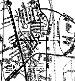 In
the hierarchical example (right), pedestrians, bicyclists and auto
users desiring to go westward from the residential development (at
center of right map) must first have to literally wind their way
eastward to leave the development, exiting on the collector (Main.
St., Milpitas), then proceed south to the arterial (Montague
Expressway) before being able to proceed westward, using the
"exressway" to cross the freeway. In contrast, there are many streets
to choose from to go in all directions in this traditional pattern
(at left) of an older part of San Jose.
In
the hierarchical example (right), pedestrians, bicyclists and auto
users desiring to go westward from the residential development (at
center of right map) must first have to literally wind their way
eastward to leave the development, exiting on the collector (Main.
St., Milpitas), then proceed south to the arterial (Montague
Expressway) before being able to proceed westward, using the
"exressway" to cross the freeway. In contrast, there are many streets
to choose from to go in all directions in this traditional pattern
(at left) of an older part of San Jose.
Stores, restaurants, and entertainment abut the street. They make an interesting environment for all modes. Car users usually parallel park on the street.
Land use is mixed, further reducing trip length and travel time. Walking, including walking portions of transit trips, is most susceptible to trip length as it relates to travel time. Most urban trips prior to 1950s (and today for many traditional cities) were by transit and walking.
Travel time for transit, bicycles, pedestrians and even most automobile trips is lower for a traditional system. While automobile speeds were also much lower than on today's arterials, travel time was less for reasons described below. (Only long distance automobile trips might be faster in a hierarchical system, but not during rush hour.)
The streets are categorized into local streets, collectors, arterials (which include expressways) and freeways. Local streets are designed with winding, random and intermittent street patterns. The purpose of this was to discourage cars from traveling on local streets and encourage them to use arterials and freeways. Stop lights end up with longer and longer cycle times the more congested the road. Arterials are "boring", with views typically limited to parking lots and advertising.
If a route becomes blocked, massive congestion results because there are few or no alternate routes with similar capacity. (In contrast, for a "traditional" street pattern, a blocked street meant that the car user, pedestrian, or bicyclist merely had to detour one block, and then proceed on his/her way.)
Freeways divide up the city, with relatively few places to cross. They became "Berlin Walls" for pedestrians.
Pedestrians and bicycles are prevented from traveling on quiet, local streets for all but immediate neighborhood destinations (see illustration). They must make major detours on account of the street pattern. The effect that a detour, designed for the car user, has on pedestrians and transit patrons was never considered by the traffic engineers. A detour designed to take a car user an extra two minutes for choosing to travel on secondary streets is equivalent to a 20-minute detour for pedestrians and transit patrons! This problem could also have been mitigated by placing alleys wherever a street contains an abrupt turn, and at "T" intersections, to permit pedestrians, transit patrons and bicyclists to proceed in their intended direction of travel. This is common in Europe, but was not done here.
Pedestrians and bicyclists are forced to use arterials, which includes expressways. In California, an "expressway" is an arterial that has few intersections (typically 1/5 as many as other arterials), few driveways, and no parked vehicles. These three special attributes provide added safety for both bicyclists and pedestrians. They also enable the expressways to be "express", decreasing the travel time. Yet, expressways have the same speed limits as other arterials (most were county roads before renaming them as "expressways"). In the past, traffic engineers instituted prohibitions on pedestrians and bicycles on expressways, even though state law only allows prohibiting them from freeways. These prohibitions, in combination with the street pattern, produce major disruptions for pedestrian, transit and bicycle travel modes.
Land use is highly categorized. Most origins and destinations are deliberately kept apart, increasing trip length and travel time.
To get to stores, people have to walk through unfriendly and boring giant parking lots. Parking lots are unfriendly not only to pedestrians and bicyclists, but also to the auto user who parks and then walks through them. Even small stores must locate in shopping centers and use huge parking lots.
Bigness is more efficient for electric power (high voltage is cheaper per power delivered), water supply or sewers (larger pipes cost less per volume carried). For these systems, smallness is required for the end user (low voltage and small pipes). These two factors result in a hierarchy, where big is connected to smaller that is connected to smallest. A hierarchical system is perfect for electric power distribution (a one-to-many system), water supply (also one-to-many) or sewer drainage (a many-to-one system), and other systems of these two types. Urban transportation is different. It is a many-to-many system.
The concept of "bigger is better" was incorrectly borrowed by traffic engineers. It is a self-serving concept, because much more construction and expense is required, and gives large contracts to the traffic engineers and road builders. However, the rewards are tenuous for automobile transportation. The excessive implementation of hierarchy for roads has actually made automobile transportation worse. It has severely worsened the situation for pedestrians, bicyclists and transit, and drastically curtailed use of these modes.
The traditional system, a network of small interconnecting streets, has greater automobile capacity and greater efficiency than fewer, wider streets with the same total number of lanes. This information is contained in the Highway Capacity Manual, the main handbook of traffic engineers. This is because of intersection delays.
A traditional system shortens the average travel distance. It also makes it much easier to combine several trip destinations into one trip (e.g., commute and errands). A traditional system offers many redundant opportunities to make left turns, and enables drivers to make "real-time" route decisions, a very efficient process. (Left-turning cars can still be passed by removing some parking spaces.) A hierarchical system gathers up left turns on arterials and forces them to single locations, giving a loss of green time to through traffic.
A traditional system has pedestrians crossing only two lanes of traffic. A six-lane hierarchical has seven to nine traffic lanes to cross (including left-turn or double-left-turn lanes, and often right-turn-only lanes). This can multiply by four the red signal time when pedestrians need to cross. It also exposes pedestrians to more hazards.
A traditional system has fewer signal lights and four-way stop signs. The need for signal lights is greatly reduced because there is much less load at any given intersection. A hierarchical arterial has higher speeds but much greater delays at intersections.
For most automobile trips, a traditional system has lower travel speeds but average travel still time less than that of a hierarchical system. For pedestrian, transit and bicycle modes, a hierarchical system often increases travel time by several times over a traditional system.
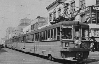 A
traditional street. The A-trains of the Key
System (shown) went between San Francisco and San Leandro. They
were articulated as light rail transit is today. The Oakland traffic
engineering department wanted trains eliminated near Lake Merritt in
an attempt to aleviate traffic congestion there. In 1950, the
"heavily used" A-line was severed, preventing trains from continuing
beyond Lake Merritt, where the tracks were converted to more
automobile traffic lanes. Eliminating the trains increased automobile
capacity, but people capacity became a small fraction of what it was
with the trains. Of course, long-term congestion was made much worse
as people were forced into automobiles. As a result of a hostile
takeover by General Motors Corp. in 1946, the transit company
supported its own destruction.
A
traditional street. The A-trains of the Key
System (shown) went between San Francisco and San Leandro. They
were articulated as light rail transit is today. The Oakland traffic
engineering department wanted trains eliminated near Lake Merritt in
an attempt to aleviate traffic congestion there. In 1950, the
"heavily used" A-line was severed, preventing trains from continuing
beyond Lake Merritt, where the tracks were converted to more
automobile traffic lanes. Eliminating the trains increased automobile
capacity, but people capacity became a small fraction of what it was
with the trains. Of course, long-term congestion was made much worse
as people were forced into automobiles. As a result of a hostile
takeover by General Motors Corp. in 1946, the transit company
supported its own destruction.Most collector streets, which today usually have four lanes and/or commercial zoning, had a streetcar line if they existed prior to the 1950s. Prior to that time, arterials and freeways rarely existed. This gives an insight to what needs to happen today.
Increasing roadway capacity involves adding more transit vehicles and/or giving signal pre-emption for transit, not adding more lanes of polluting and inefficient automobiles, or destroying productive land with freeways, arterials and parking lots. This means that roadway capacity is defined in terms of moving people (contrasted with moving motor vehicles).
The traditional system, with destinations abutting the street, is ideal for light rail transit. It is still common in Europe today to walk out of a supermarket on to a streetcar stop with a bag of groceries. The distance is less than walking across most of a typical mall parking lot. Small neighborhood markets are also very common.
Automated Guideway Transit (AGT), sometimes called People Movers, a new form of guideway transportation, needs to be evaluated for future guideway transit projects. Like light rail transit, pedestrian and bicycle travel modes, AGT is much more compatible with a traditional, rather than hierarchical, system.